Imagine this; you’re trying to communicate information about a location to a colleague. You take a screenshot of a map and mark it up by denoting important areas. This is a quick way to communicate, but these markings aren’t technical and it will eventually be lost in the multiple email threads you get per day. What if someone leaves the company? How will you retrieve that note with your instructions or information? We hear about these innovative “hacks” all the time and we know that it is the result of resourceful and smart people making the best with their technology. How we collect and share information must be efficient, easy, and accessible. Fortunately, innovative tools in project management for field-based services are simplifying things. Real-time access to maps in the field reduces errors and saves time. Accessing geographic data and maps in the palm of your hand is essential for spatial awareness and accurate project completion.
Geographic information systems (GIS) are a universal data language used in almost all industries to communicate and analyze geographic data. GIS informs project managers at all stages and by empowering its ease of access and efficiency, so too can a project be simplified. Civil, energy, oil, gas, environmental, and urban planning are only some of the industries that must manage data between the office and the field. Collecting and analyzing data, especially geographically technical data, has often been done on complex desktop software, or paper maps, and has often involved technical members of the team. Further, financial information about a project is usually organized by the accounting department and unavailable in real time. Innovative technology, Mobile GIS, is simplifying project management by removing barriers of access to information and streamlining operations. Mobile GIS is simplifying project management through increased access to information, budget and data insight, and streamlined operations. Read on to learn how this easy-to-use, cloud-based, and secure platform is eliminating complexity.
Immediate Access to Information
Accessing important information is critical for making timely decisions and giving regular updates to clients and vendors. Mobile GIS eliminates the need to store information locally on a device, and that means that you can connect and access accurate maps anywhere through secure cloud-based storage. The ability to access information and work asynchronously ensures a strong and seamless connection between office and field. The ability to input and organize data without looping in a senior GIS field technician makes intuitive GIS options the smart solution. To simplify field project management, maps and data must be accessible not just geographically from the field and office, but also accessible to team members in its ease of use for different professional backgrounds.
It’s desirable to have increased efficiency and access to timely information, but the ability does exist to limit information. Controlling access to certain aspects of a project including budget or sensitive industry information is made possible through layers of access. Allow others to view and contribute while controlling the information they’re allowed to see. Through this, you can share a map-based project view with your entire team to ensure everyone is on the same page.
Manage Your Budget
Technology that reduces redundancies, errors, and time spent in the field ultimately impacts a project’s bottom line. Improving efficiencies allows team members to focus on more high-value contributions and overall project needs instead of administrative tasks. Through the implementation of mobile GIS, you will save not only your team’s time but reduce transcription errors. Missing data or having to visit the site multiple times to collect data is also reduced when the collection is made securely in the cloud from your site.
Mobile GIS often has integrations with third-party accounting software that will allow you direct and real-time insight into a project’s financials. The ability to broadly view a project’s budget as well as specific line items is helpful in ensuring you’re operating within budgets. It is possible to have more timely insights into the overall budgets of a project without having to loop in the accounting department when financials are available in real time. Through increased access to information, details for timely invoices can be accessed for quicker payment turnaround.
Visualize Your Data
The only complexity you should enjoy in the field is a rich and complex picture of your surroundings laid out on a map. Spatial awareness is important for accuracy and safety, and with mobile GIS software, you’ll have a bird’s-eye view of all your projects. Visualizing your project as it relates to surrounding communities, natural areas, and hazards builds a complete picture that can inform project goals. Understanding a project as it exists in its geospatial context helps bring to light potential risks which ultimately ensures success and budget alignment.
The aggregation of data is the most important benefit afforded by mobile GIS software. When mobile workers are contributing on one platform, it is easier to immediately access the collaborative data to analyze and make decisions. Eliminating paper entries or multiple redundancies means information is collected quicker and decisions can be made faster. Less time spent on administrative work means you’ll enjoy more time for higher-value tasks like client collaboration and project implementation.
Streamline Your Daily Operations
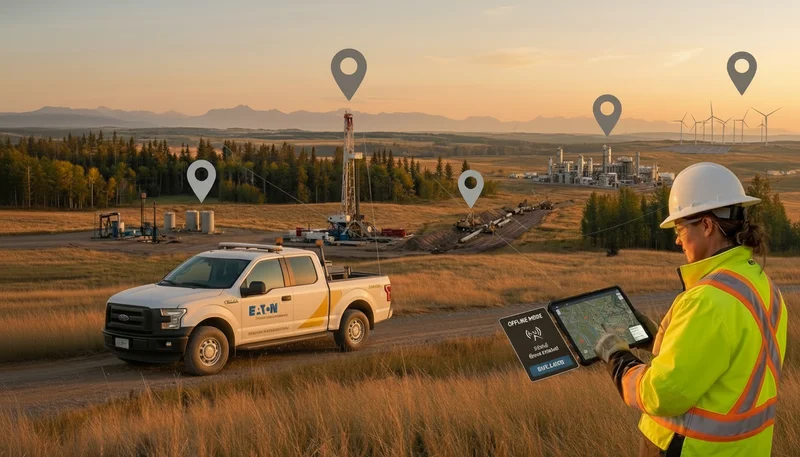
While some mobile GIS options offer a remote form of highly technical data, some platforms can be cumbersome and complex to use. Connect the office and field by using a one-stop shop for information and improve your overall efficiency by reducing redundancy. Manually taking notes, especially in the field, is time-consuming and inefficient and can lead to lost or incorrect data. Securely storing data collected in the field through customized forms or reports means inputting data only once. Remote technicians enjoy offline functionality with mobile GIS that will keep them connected to the data and collaborating even if their signal is not.
Recent limitations in labour availability has highlighted the need for operational efficiency more than ever. All industries are impacted by a reduced bandwidth to onboard new mobile workers or oversee technicians in the field. Ensuring data is securely stored in one place allows for less disruption to workflows if someone should no longer be with the company. Implementing mobile software that is easy to use and involves little to no training means getting started is easy and will not use up your valuable resources.
.webp)
.webp)
.webp)
%20(2).webp)
.webp)
.webp)


.webp)

.webp)

.jpg)


%20(1).webp)


.jpg)

.jpg)
.jpg)
.jpg)


.jpg)