Stop Missed Services, Documentation Chaos, and Crew Visibility Gaps
Track every corridor segment in real-time. Coordinate multiple crews on a shared live map. Eliminate late-night reconciliation. Manage year-round vegetation management programs without spreadsheet chaos.

Overview
When you run vegetation management programs across hundreds of kilometers of right-of-way, coordination failures are expensive. Multiple crews survey the same segments. Missed services slip through without anyone noticing until client deliverables are wrong. Managers reconcile documentation past midnight to keep up with daily field output.
Matidor gives every crew member and back-office manager a shared live view of the entire corridor. Field technicians collect data offline in areas with zero cellular coverage. Managers see completed and outstanding segments in real-time without waiting for end-of-day reports. Missed services get spotted and reassigned before they become compliance failures.
Trusted by Environmental Consulting Teams Worldwide


.png)


.png)


What Missed Services, Scattered Documentation, and Crew Blindness Actually Cost You
Missed Services Discovered After Client Deliverables Are Wrong
Your crews survey hundreds of segments simultaneously across long corridors. Two technicians cover overlapping sections. A third skips a segment that looked completed on the whiteboard. Nobody catches it until the client's deliverable comes back with gaps.
Under traditional systems, there is no shared view of who covered what. Supervisors track progress through end-of-day check-ins, verbal updates, and spreadsheets that lag behind reality. By the time a missed service surfaces, the crew has moved on, the schedule has shifted, and fixing it requires a return trip that shouldn't have been necessary.
Missed services create rework. Rework erodes margins. Repeat errors damage client relationships.
Documentation Reconciliation Runs Past Business Hours
Multiple technicians submitting data through disconnected apps, or worse, paper forms, forces someone on the back-office team to manually consolidate everything. Different crews use different formats. GPS coordinates are missing. Count data requires manual aggregation from separate exports.
What should take minutes takes hours. Managers and foremen end up processing documentation late into the night to prepare client reports and billing summaries for the following morning. This isn't a workflow problem. It's a systems problem.
You Can't See the Corridor. You Can Only Hear About It
When multiple crews work simultaneously across the same right-of-way, the only way to know what's been completed is to call them. Segment-level status lives in a foreman's head or in a spreadsheet that's four hours out of date.
You have no shared map. No live view of which segments are done, in progress, or outstanding. Compliance gaps don't surface until someone reviews the data, which is often too late for that day's work to be corrected without mobilizing crews again.
Regulatory and Client Reporting Takes Days to Compile
Vegetation management programs for utilities and pipeline operators require detailed documentation: GPS-tagged observations, treatment records, clearance measurements, and evidence of compliance with standards. When that data is scattered across paper forms, personal devices, and multiple apps, compiling a compliant report is a multi-day manual effort.
Inconsistent data collection formats across crews make every reporting cycle start from scratch. No two technicians document the same segment the same way.
How Matidor Solves These Problems
Shared Map Visibility, Offline-First Field Collection, and Real-Time Crew Coordination
Unlike spreadsheets and disconnected GIS tools that require manual reconciliation, Matidor gives the back office live visibility into exactly what field crews have completed. Unlike generic project management apps, Matidor works 100% offline in remote corridors with zero cellular coverage. Unlike legacy GIS platforms, Matidor requires no workarounds — crews tap one button to sync and move on.
Shared Live Map Eliminates Missed Services
Every crew member's progress appears on a shared real-time map the moment data syncs. Managers see completed segments, outstanding segments, and any gaps without calling anyone. When a missed service appears on the map, it gets assigned and tracked in-platform before it becomes a deliverable error.
"Helped us spot missed services and assign tasks to handle them."
— Andrew Morley, Manager of Pipeline Integrity and Emissions, West Country Energy Services
Offline-First Mobile Apps Built for Remote Corridors
Custom forms are preloaded on mobile devices before crews leave the yard. Technicians collect GPS-tagged observations, photos, treatment records, and count data completely offline across remote pipeline and utility corridors. One tap syncs everything when connectivity returns — replacing multi-step upload processes that created daily friction.
Every data point is automatically GPS-tagged with timestamps, giving the back office location context on every entry without extra effort from field crews.
.avif)
.png)
Count Data Aggregation Goes from Hours to Minutes
Aggregating survey counts from multiple crews used to require a manual process that could consume an hour or more per reporting cycle. In Matidor, the same aggregation takes a few clicks. Field data captured across all technicians flows into one centralized database, ready for reporting the moment it syncs
Back-office teams stop working past midnight. Documentation gets done within business hours.
Real-Time Budget Tracking Across the Program
Vegetation management programs run on tight unit-rate or lump-sum contracts. Every extra mobilization, return trip, or overtime hour chips away at margins. Matidor tracks crew time and equipment costs as they're logged in the field. Budget alerts trigger automatically at 70%, 90%, and 100% of allocation before overruns lock in.
Program managers know their cost position against the contract budget in real-time — not when the invoice arrives.

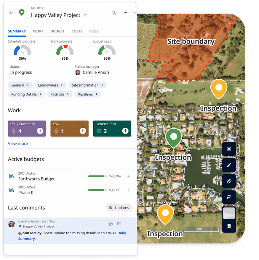
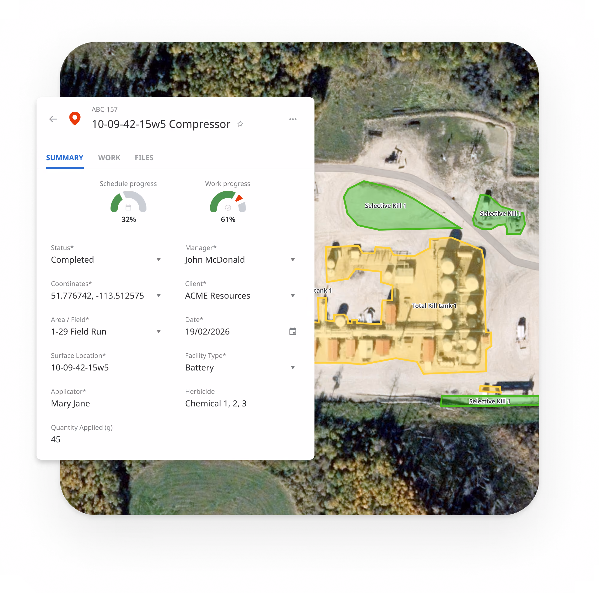
Corridor Visualization With Regulatory and Environmental Layers
All right-of-way segments, treatment zones, and assessment sites display on interactive maps with multi-layer visualization. Overlay regulatory clearance zones, environmental restrictions, land ownership, species-at-risk constraints, and permit boundaries on the same map. See complete corridor context, not just where crews are, but what conditions govern each segment.
Vegetation Management Teams Using Matidor


.webp)


Real Results from Real Operations

Project Forest Case Study

NorthWind Case Study

West Country Case Study
Vegetation Management Operations Using Matidor
Right-of-Way Survey and Inspection Programs
Vegetation management contractor runs annual ROW surveys for a pipeline operator across 600 kilometers of corridor. Multiple crews work simultaneously across separate segments. Back-office team responsible for daily client reporting.
Before Matidor: Crews use paper forms and a legacy GIS app that requires constant workarounds. Missed segments discovered after client reports submitted. Count data aggregation takes an hour per cycle. Managers reconcile documentation past 2 a.m. No shared view of corridor progress.
With Matidor: Custom inspection forms preloaded on mobile before crews depart. All crews visible on shared live map as work progresses. Missed segments flagged proactively and reassigned in-platform. Count data aggregates automatically across all technicians. Documentation complete within business hours.
Result: Missed services eliminated. Documentation burden reduced significantly. Client deliverables produced faster with greater accuracy. Back-office team reclaims evenings.


Utility Transmission Corridor Vegetation Management
Electric utility manages compliance vegetation programs across 1,200 kilometers of transmission ROW. Multiple contracted crews execute trimming and removal. Compliance documentation required for regulatory audit.
Before Matidor: Contractor submits paper-based or PDF inspection reports. Compliance documentation manually compiled from multiple sources before regulatory submissions. No shared visibility into segment-level completion status. Environmental constraints tracked in a separate GIS system.
With Matidor: Each ROW segment tracked as a project task with GPS coordinates and status. Contractors submit standardized mobile forms with GPS-tagged photos and treatment records. Regulatory clearance zones, environmental constraints, and species-at-risk areas overlaid on corridor map. Compliance documentation generated from current data, compressing audit preparation from days to minutes.
Result: Compliance documentation audit-ready. Corridor visibility complete with regulatory context. Contractor coordination standardized. Submission timeline shortened.
Seasonal Integrated Vegetation Management (IVM) Programs
Vegetation management firm delivers integrated programs combining mechanical treatment, herbicide application, and inspection for multiple utility and pipeline clients. Multiple seasonal crews, varying treatment methods, strict environmental permit conditions.
Before Matidor: Treatment records tracked per crew in separate spreadsheets. Herbicide application data entered manually into compliance logs after the fact. Environmental exclusion zones referenced from paper maps. Budget tracked monthly through accounting with overruns discovered after crews have already worked.
With Matidor: Treatment type, product, rate, and location captured via standardized mobile form for each application. Environmental exclusion zones loaded onto corridor map and visible on field crew devices. Budget tracked in real-time per program and client. Photo documentation GPS-tagged and timestamped automatically. Reports generated directly from field data.
Result: Treatment documentation compliant and complete. Environmental exclusion zones enforced in the field. Billing backed by complete field records. Budget position known at all times.

Frequently Asked Questions About Environmental Project Management Software
Matidor's shared live map shows every crew member's completed segments, active tasks, and outstanding work simultaneously. Supervisors assign tasks directly in the platform, track completion in real-time, and flag missed segments before end of day — without relying on phone calls or verbal check-ins. The map updates as crews sync, giving the back office accurate corridor status at any moment.
Yes, completely. Mobile apps load custom forms and corridor maps before crews leave the yard. All data collection, GPS-tagged photos, count data, inspection forms, treatment records, happens fully offline. One tap syncs everything when the device reaches connectivity. No multi-step upload process, no manual transfer.
Yes. Configure strict data isolation between clients. Field crews access only the specific programs and corridors assigned to them. Client-facing views show only their project data. Internal budget, cost, and operational data stays hidden from client accounts. Complete confidentiality with role-based permissions and audit trails.
Load regulatory clearance zones, environmental constraints, and permit boundaries as map layers visible to field crews in real-time. Standardized inspection forms enforce required documentation fields for every segment. GPS-tagged photos and timestamps create automatic audit trails. Compile compliance reports directly from field data rather than manual assembly. Deadline reminders prevent missed regulatory submissions.
Yes. Create contractor accounts with role-based access restrictions. Contractors access only their assigned segments and programs without seeing your full portfolio, client data, or financial information. All submissions flow through the same standardized forms, eliminating consolidation work caused by contractors using different systems.
Most vegetation management teams are fully operational within 4-6 weeks. Typical timeline: 2 weeks for discovery and custom form configuration, 2 weeks for field crew training and pilot testing, then full program deployment. Forms can be configured to match your existing data collection requirements, regulatory obligations, and client deliverable formats.
Yes. Create separate custom forms for each treatment type with the fields required for each — treatment method, product, rate, application date, operator, GPS location, environmental conditions. All treatment types flow into the same program database, giving you a complete record of corridor work regardless of method. Reports can be filtered by treatment type, date, crew, or corridor segment.
Build herbicide application forms with required fields: product name, EPA registration number, application rate, target species, buffer zone confirmation, applicator license number, and GPS-tagged location. Every application creates a timestamped, GPS-referenced record. Environmental exclusion zones load onto the map so crews confirm buffer distances before applying.
Yes. Create projects for each program year or treatment cycle. Track segment status (surveyed, treated, completed, pending re-inspection) with complete history across cycles. Historical records stay searchable and accessible for ongoing compliance reference, regulatory audit response, and multi-year cycle planning.
Field data collected by crews flows directly into reports. Generate corridor progress summaries, treatment records, GPS-mapped completion status, and compliance documentation from current data with a few clicks — rather than manually assembling information from multiple sources. Reports include embedded maps, photos, and timestamps at deliverable quality.
See Matidor in Action With Your Corridor Programs
Schedule a Discovery Call
Schedule a 30-minute personalized demo. We'll walk through your specific workflows: how crews would collect data offline in remote corridors, how the shared map would show real-time segment completion, how budget tracking would prevent program overruns, and how compliance documentation would generate directly from field data.
You'll See:
- Your corridor segments displayed on interactive maps with regulatory layers and environmental constraints
- How multiple crews appear simultaneously on a shared live map with real-time completion status
- How offline mobile forms would replace paper and legacy GIS apps for your field technicians
- How program budget tracking keeps you ahead of contract allocations before overruns happen
Or Start Free for 14 Days
Get full platform access immediately. Import your current projects. Test mobile apps with your field crews. See real results with your own data.
- Full access to all platform features
- Live chat support during trial
- No credit card required
- Cancel anytime