
Overview
Managing a portfolio of 50 or more concurrent field projects is fundamentally different from managing a handful of office-based initiatives. Spreadsheets and email threads feel manageable at five projects and start to break down at 10 to 20. Beyond that threshold, "portfolio management" devolves into chasing status updates, stitching together reports, and reacting to budget overruns that were already weeks in the making.
This playbook covers the core disciplines operations leaders and PMOs need to manage large-scale field project portfolios in 2026, from portfolio visibility and standardization to GIS-native dashboards and real-time budget control.
Why Field Portfolio Management Is Different
The Scale Problem
Standard project portfolio management frameworks were designed for office-based or digital project work. Field operations introduce variables that those frameworks do not account for: remote sites with no connectivity, contractor-led workforces, regulatory overlays, and physical assets spread across hundreds of kilometers.
When a portfolio scales past 50 active sites, the following problems consistently emerge:
- No single source of truth across projects, regions, and contractors
- Status reports that are outdated before they are distributed
- Budget overruns that surface weeks after the threshold was crossed
- Resource conflicts invisible until a team is already double-booked
- Field data that arrives days or weeks after work is completed
Why Spreadsheets Break at Scale
Spreadsheets work at five projects. They start to create risk at 20. At 50-plus active sites, a spreadsheet-based system means your portfolio view is only as current as the last person who updated it, budgets are tracked in isolation rather than against the full portfolio, and field teams are re-entering data that already exists somewhere else.
The Four Pillars of Field Portfolio Management
1. Centralize: One Dashboard for Every Active Site
The first requirement for managing 50-plus field projects is a single place where every project lives. Not a folder of workbooks. Not a shared drive with status decks. A live portfolio dashboard that surfaces project health, budget status, milestones, and team assignments across every active site simultaneously.
Effective portfolio dashboards for field operations include:
- Color-coded project status so attention goes where it is needed
- Budget summaries at both the project and portfolio level
- Timeline and milestone tracking across all active sites
- Contractor and team assignment visibility
- Geographic context showing where every project sits relative to others
Matidor's portfolio dashboard delivers portfolio visibility that scales from 10 to 100-plus projects without adding complexity, surfacing every project's health at a glance.
2. Standardize: Enforce Best Practices Across Every Site
Portfolio management at scale requires standardization. When every project team builds their own forms, workflows, and reporting formats, the portfolio view becomes impossible to aggregate meaningfully. Standardization means custom workflows that enforce consistent processes, templated forms that produce comparable data across sites, and permission structures that give contractors access to exactly what they need.
Key standardization levers for field portfolios:
- Standardized project templates by work type (remediation, inspection, construction, maintenance)
- Custom workflows that enforce approval gates and sign-offs before work advances
- Consistent budget categories and cost codes across all projects
- Standardized field forms that produce structured, comparable data
3. Automate: Eliminate Manual Reporting and Status Chasing
The biggest time drain in multi-site portfolio management is manual reporting: collecting status updates, assembling portfolio reports, and reconciling budget actuals against estimates. Automation replaces that cycle with real-time data that flows from the field to the dashboard without human intervention.
Automation priorities for field portfolios in 2026:
- Automated budget alerts at 70%, 90%, and 100% of AFE or budget thresholds
- Real-time field data sync from mobile devices to the central platform
- Automated status updates triggered by task completions and milestone sign-offs
- Portfolio-level reporting that aggregates live data rather than collected responses
Matidor's budget management tools provide real-time budget tracking with automated threshold alerts, eliminating the lag between budget overrun and awareness.
4. Visualize: See the Whole Portfolio on One Live Map
Geography is the most underused dimension in field portfolio management. When every active site appears on a live map with real-time status overlaid, portfolio decisions become spatial as well as operational. Questions like "Which region is trending behind on compliance inspections?" and "Where are we overcommitted on contractor capacity?" become answerable in seconds rather than hours.
A GIS-native portfolio view provides:
- All active projects and sites mapped in real time
- Regulatory zones, right-of-way corridors, and environmental constraints layered onto the portfolio map
- Color-coded project health visible geographically
- Asset disposition and infrastructure context for every site
- Geographic clustering of risk, resource demand, and budget exposure
Matidor's Location Intelligence maps the entire project portfolio geographically with multi-layer visualization, so geography becomes an operational advantage rather than an afterthought.
Portfolio Visibility by Industry
Oil and Gas
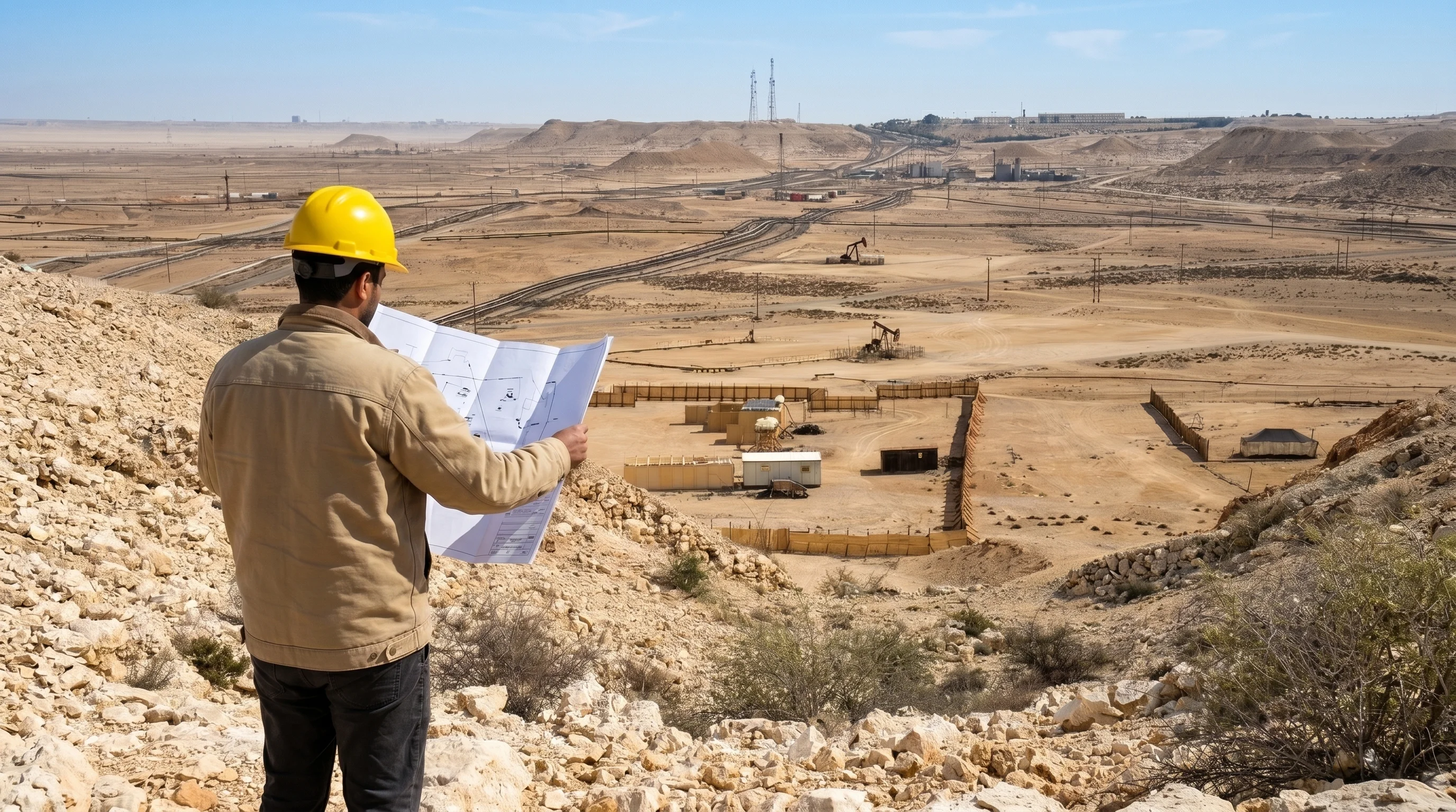
Oil and gas field portfolios typically combine active wells, facility maintenance programs, pipeline integrity projects, and environmental compliance work running simultaneously across multiple regions. The portfolio challenge is not just volume, it is the mix of work types, the pace of regulatory change, and the need for real-time budget control against AFE limits.
Effective GIS project portfolio management for oil and gas means overlaying regulatory zones and buffer areas directly onto the portfolio map, so proximity risks are visible before they become compliance events.
Environmental Consulting
Environmental consulting portfolios are characterized by strict regulatory milestones, Phase I and Phase II assessment timelines, and multi-stakeholder reporting requirements. Portfolio dashboards need to surface which sites are approaching regulatory deadlines, which are waiting on lab results, and which are ready to close, all at once.
Matidor's executive project portfolio visibility solution is built specifically for this type of multi-milestone, multi-site portfolio.
Multi-Site Infrastructure
Infrastructure portfolios spanning civil engineering, utility construction, or municipal programs face resource conflicts as the primary risk. Scheduling three major site mobilizations simultaneously can paralyze a team that looks adequately staffed on paper. Portfolio-level scheduling that accounts for resource demand across all active sites is the intervention that prevents this.
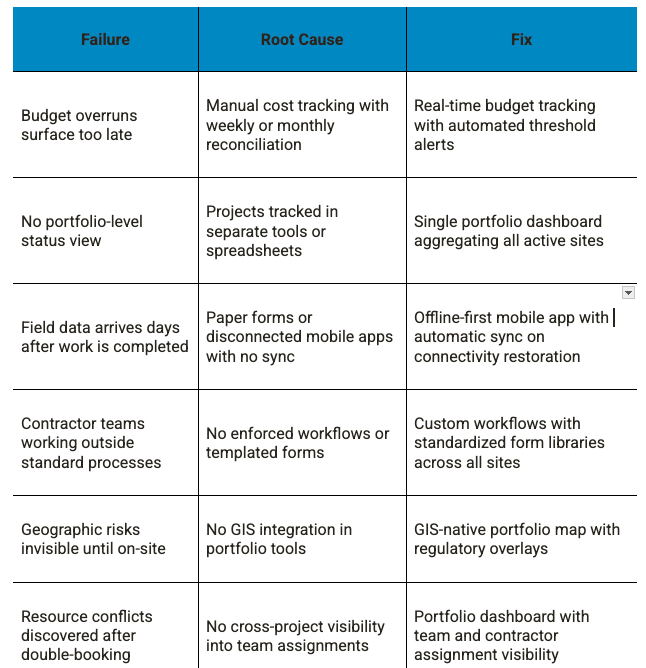
Common Portfolio Management Failures (and How to Fix Them)
What a Real Field Portfolio View Needs to Include
Based on the operational realities of managing 50-plus concurrent field projects, a portfolio view must provide the following at a minimum:
- Live project status for every active site, updated from the field without manual re-entry
- Portfolio-level budget summary with real-time actuals against estimates for every project
- Geographic portfolio map with all active sites visible and layered with relevant regulatory and infrastructure context
- Milestone and timeline tracking across all projects with deadline visibility at the portfolio level
- Team and contractor assignments visible across projects to surface resource conflicts before they occur
- Standardized field data flowing from mobile devices directly into the portfolio dashboard
Matidor's platform unifies all of these capabilities on one platform, replacing disconnected spreadsheets, static maps, and siloed mobile apps with a single live view of every project, site, and budget.
How to Build Your Field Portfolio Management System
Step 1: Audit Your Current Portfolio Visibility
Before selecting or configuring tools, assess what your current system actually provides. How current is your portfolio status view? How long does it take to answer "What is the budget status of every active project?" If the answer is hours or days, your portfolio is running on a lag that creates preventable risk.
Step 2: Standardize Project Templates and Workflows
The fastest path to portfolio visibility is standardizing what projects look like before they start. Define standard project templates by work type, standard budget categories, and the workflow gates that every project must pass through. This makes aggregation possible because every project is structured the same way.
Step 3: Move Field Data Collection Off Paper
Paper forms and disconnected spreadsheets are the single biggest source of lag in field portfolio management. Moving field teams to an offline-first mobile app with structured forms and automatic sync eliminates re-entry, reduces errors, and means portfolio data reflects what is actually happening in the field.
Step 4: Configure Portfolio-Level Dashboards and Budget Alerts
Set up portfolio dashboards that aggregate project health, milestone status, and budget actuals across every active site. Configure automated budget alerts so threshold crossings surface immediately rather than appearing in the next weekly report.
Step 5: Evaluate Platform Fit for Your Operation
Matidor's platform evaluation tool walks operations leaders through the specific scenarios, capabilities, and typical outcomes for portfolios of 30-plus active field projects, making it easier to assess whether a GIS-native platform fits before committing to a migration.
Ready to See Your Entire Portfolio on One Live Map?
If you are managing 50-plus active field sites and your current system runs on spreadsheets, email threads, and status calls, Matidor can help.
See Matidor in your operation:
- Start a free 14-day trial and map your first 10 projects in under an hour
- Book a demo to see portfolio dashboards, budget tracking, and GIS overlays configured for your workflows
- Evaluate platform fit with Matidor's self-guided discovery tool built for multi-site operations
.webp)
.webp)
.webp)
%20(2).webp)
.webp)
.webp)


.webp)


.jpg)


%20(1).webp)


.jpg)

.jpg)
.jpg)
.jpg)


.jpg)