
The Real Cost of the Wrong Software Decision
Most field operations teams discover the wrong software purchase six to twelve months after signing — when mobile adoption has stalled, workarounds have multiplied, and the platform is running alongside the spreadsheets it was supposed to replace.
A buyer's guide built around feature comparisons will not prevent that. The platforms that look strongest in a demo are often built for office-based workflows and adapted for field use as an afterthought. This guide covers the six operational criteria that actually determine whether a platform works in the field and a framework for evaluating any vendor against them.
Why Generic Software Fails Field Operations Teams
Field operations teams have requirements that do not appear in standard project management or FSM comparisons:
- Sites are geographically distributed, often remote, often with no connectivity
- Regulatory context is location-specific and changes at the site boundary level
- Budget accountability runs against AFEs or project cost codes, not general expense categories
- Compliance documentation must be spatial, timestamped, and auditable
- Contractor and consultant access requires controlled portals, not full system licenses
- Reporting must be client-ready and regulator-ready, not just internal
Generic tools handle none of these requirements natively. They require workarounds, integrations, and manual processes that recreate exactly the fragmentation the software was supposed to solve.
Six Criteria That Actually Matter for Field Operations Software
1. Is It GIS-Native or GIS-Bolted?
The single most important distinction in field operations software is whether geographic capability is built into the platform's architecture or added as a map widget.
A GIS-bolted platform shows project locations on a map. A GIS-native platform structures all data, including projects, budgets, compliance records, and field events, around geographic context as the primary organizing dimension. For oil and gas and environmental teams, the difference is operational: GIS-native platforms let you overlay regulatory zones on your active project portfolio, see which sites are approaching sensitive area buffers, and verify that field data was captured at the correct location. GIS-bolted platforms cannot do any of this without manual workarounds.
When evaluating vendors, ask specifically whether GIS is native to the data model or a visualization layer built on top of a generic project structure.
2. Does Offline Mode Actually Work?
Every field operations software vendor says their platform works offline. Most do not mean the same thing by it.
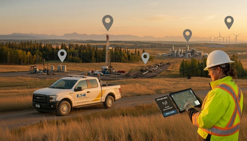
The test is straightforward: put the device in airplane mode and try to complete a full compliance form, attach a GPS-tagged photo, and save the record. If any of those steps fail, or if the data does not carry the original field timestamp when it syncs, the platform is not genuinely offline-first. For teams working at remote well sites, environmental monitoring locations, and reclamation areas, a platform that fails the airplane mode test is not a field operations platform. It is an office platform with a mobile app.
3. Can It Handle Real-Time Budget Tracking Against AFEs or Project Cost Codes?
Budget visibility in field operations is not a reporting function. It is an operational control. When cost data is 5 to 7 days behind actuals, operators are making capital allocation decisions on stale information and discovering overruns at invoice reconciliation rather than during the project.
The right platform connects cost entry at the point of work to the specific AFE or project cost code, with automated alerts before thresholds are crossed. It also provides a portfolio-level view of budget status across all active projects without manual compilation.
4. Does It Support Contractor Access Without Full Licenses?
Field operations teams routinely coordinate third-party contractors, consultants, and subcontractors who need access to work orders, site documentation, and reporting tools. They should not have full access to financial data, project settings, or other clients' work.
Platforms that require a full license for every external user create cost barriers that force teams to share credentials or revert to email coordination, undermining the platform's workflow value entirely. The right platform provides role-based contractor portals that give external teams precisely the access they need.
5. How Fast Can the Team Actually Implement It?
Enterprise field operations platforms often advertise comprehensive capabilities alongside 6 to 12 month implementation timelines. For a field operations team with active projects and no dedicated IT resources, that timeline is a disqualifier.
The right platform is configured by the operations team, not implemented by a professional services firm. Look for platforms with 4 to 6 week onboarding timelines, self-guided setup, and support resources designed for non-technical operations staff.
6. Is It Built for Your Industry or Adapted From Another?
Field operations software built for facilities management, construction scheduling, or generic project management is not the same as a platform built for oil and gas abandonment programs or environmental site assessments.
Industry-specific platforms arrive with the workflows, form libraries, regulatory vocabulary, and integration patterns your team needs. Generic platforms require those to be built from scratch, consuming implementation time and creating maintenance obligations that persist for the life of the system.
Evaluation Framework: Questions to Ask Any Vendor
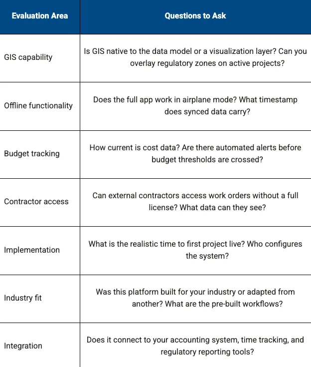
What to Look for in a Platform Built for Field Operations
The strongest platforms in this category share a consistent set of characteristics: GIS-native architecture with multi-layer regulatory visualization, 100% offline-first mobile with auto-sync and device-locked GPS timestamps, real-time budget tracking with automated threshold alerts, contractor portals with role-based access, a 4 to 6 week implementation timeline, and industry-specific workflows for oil and gas, environmental services, and multi-site infrastructure.
Matidor was recognized as a SourceForge Spring 2026 Top Performer — an award based on verified user reviews from operations teams actively using the platform in the field. The Matidor comparison page provides a side-by-side breakdown of how these capabilities stack up against generic project management and FSM tools.
Related Reading
- Time-Tracking, Accounting and Project Management in Field Operations
- Project Portfolio Management for Field Operations
- 2026 Field Operations Trends: GIS and Offline Mobile
- How to Manage 50+ Field Projects Without Losing Control
Ready to Evaluate Your Options?
- Evaluate platform fit with a self-guided discovery tool built for multi-site field operations
- Book a demo to see GIS mapping, offline mobile, and budget tracking configured for your workflows
Start a free 14-day trial and test the platform against your real projects
.webp)
.webp)
.webp)
.webp)
.webp)
.webp)
.webp)
.webp)
.webp)
.webp)
.webp)
.webp)
.webp)
.webp)
%20(2).webp)
.webp)
.webp)
















.webp)

.webp)

.jpg)


%20(1).webp)




.jpg)

.jpg)
.jpg)
.jpg)


.jpg)